Indonesian Cuisine


Indonesian cuisine is one of the most vibrant and colourful cuisines in the world, full of intense flavour. It is diverse, in part because Indonesia is composed of approximately 6,000 populated islands of the total 18,000 in the world's largest archipelago, with more than 300 ethnic groups calling Indonesia their home. Many regional cuisines exist, often based upon indigenous culture and foreign influences. Indonesia has around 5,350 traditional recipes, with 30 of them considered the most important. Indonesia is home to a large number of mouth-watering foods; from affordable rice, noodle and soup dishes in warungs (local diners) to street-side snacks and top-dollar plates.
In 2011, Indonesian cuisine began to gain worldwide recognition, with three of its popular dishes make it to the list of 'World's 50 Most Delicious Foods (Readers' Pick)', a worldwide online poll by 35,000 people held by CNN International. Rendang top the list as the number one, followed closely by nasi goreng in number two, and satay in number fourteen. You must try all the food....
Indonesian cuisine varies greatly by region and has many different influences.Sumatran cuisine, for example, often has Middle Eastern and Indian influences, featuring curried meat and vegetables such as gulai and kari, while Javanese cuisine is mostly indigenous, with some hint of Chinese influence. The cuisines of Eastern Indonesia are similar to Polynesian and Melanesian cuisine. Elements of Chinese cuisine can be seen in Indonesian cuisine: foods such as bakmi (noodles), bakso (meat or fish balls), and lumpia (spring rolls) have been completely assimilated.

Gambar terkait
Throughout its history, Indonesia has been involved in trade due to its location and natural resources. Additionally, Indonesia’s indigenous techniques and ingredients were influenced by India, the Middle East, China, and finally Europe. Spanish and Portuguese traders brought New World produce even before the Dutch came to colonise most of the archipelago. The Indonesian islands The Moluccas (Maluku), which are famed as "the Spice Islands", also contributed to the introduction of native spices, such as cloves and nutmeg, to Indonesian and global cuisine.
Indonesian cuisine often demonstrates complex flavour,acquired from certain ingredients and bumbu spices mixture. Indonesian dishes have rich flavours; most often described as gurih (savory which equate to umami) and pedas (hot and spicy), and also combination of basic tastes such as manis (sweet), asin (salty), asam (sour) and pahit (bitter). Seven main Indonesian cooking methods are goreng (frying), bakar (roasting) or panggang (grilling), tumis (sautéing), sangrai (roasted), rebus (boiling) and kukus (steaming).
Some popular Indonesian dishes such as nasi goreng,gado-gado,sate,and soto are ubiquitous in the country and considered as national dishes. The official national dish of Indonesia however, is tumpeng, chosen in 2014 by Indonesian Ministry of Tourism and Creative Economy as the dish that binds the diversity of Indonesia's various culinary traditions.
Today, some popular dishes that originated in Indonesia are now common to neighbouring countries, Malaysia and Singapore. Indonesian dishes such as satay, beef rendang, and sambal are favoured in Malaysia and Singapore. Soy-based dishes, such as variations of tofu (tahu) and tempe, are also very popular. Tempe is regarded as a Javanese invention, a local adaptation of soy-based food fermentation and production. Another fermented food is oncom, similar in some ways to tempe but using a variety of bases (not only soy), created by different fungi, and particularly popular in West Java.

Hasil gambar untuk indonesian cuisine

KELIMUTU


There are outstanding natural beauty phenomenon like no other in three lake's crater which constantly changing color. Natural Wonders was built by geological activity in KElimutu mountain, Flores. KElimutu is a combination of the word "KELI" meaning mountain and "MUTU" which means boiling.


This volcanic lake are considered as magical and mysterious lakes, because it has 3 colors and constantly changing color. Earlier this lake is red, white and blue. In mid-2006 and occurred several times, especially two adjacent lakes namely Lake Spirits Youth (Tiwu nua ko'o fai muri) and Lake Spirits soothsayer (Tiwu ata polo). Young Spirit Lake previously green, in June last year had turned blue. While Lake soothsayer or Evil People which previously dark brown changing to reddish.

A separate lakes, Spirits Parents Lake(Tiwu Ata Mbupu) which has a dark green and moss, but then turns back to green,old evilman lake turned to dark brown, and the parents lake became blackish brown. A good time to watch the lake Flores is in the morning, because the fog usually blocks the view around the lake in the noon.

Lake Kelimutu (Flores) believed as a place of the spirits. On some occasions there is usually a ceremony of the local community and give offerings to the "spirit" which keeps the region. Local people believe that Kelimutu is sacred and give fertility to the surrounding nature.

Kelimutu had erupted in 1886 and left three crater-shaped lake, the lake is the third area roughly around 1.051 million square meters with a volume of 1292 million cubic meters of water. Boundary between the lakes with each other is a narrow stone walls that prone to landslides.

The steep walls of a 70-degree angle with a height of between 50-150 meter.Kelimutu has a relatively stable tropical climate with rainfall ranging from 1651 up to 3363 mm per year, the rainy season falls in December to March and the dry season occurs in October to November. Temperatures ranged from 25.5 ° - 31 ° Celsius with the minimum temperature reached 11.6 degrees which occurred in July-August. In the rainy season, all plants are green and lush during the dry season many plants that grow leaves. Soil and climate conditions are highly influential on the existing flora and fauna.

However, some society believe, changing the color of Lake kelimutu associated with predictions of impending critical events in Indonesia, or in Ende. "From the stories the old people used to, anyway if the color of lake changing menaing the lake is giving signal there will be a disaster. But it may also influence the weather that now rapidly changing, "said Yulita, villagers in Flores.

On 13 until May 31, 1997,lake Tiwu Ata Polo changed its color as well. than, the incident by some people considered connected with the fall of President Suharto in 1998 .

Similarly, the incident in December 2008 when Tiwu Ata Polo changed color from dark green to blackish brown, the events associated with legislative and presidential elections, as well as the earthquake in Tasikmalaya (West Java)and Sumatra (Andalas).


http://dougfurtek.com/Indonesia2002.html

GREEN CANYON IN INDONESIA WEST JAVA


If America had the Grand Canyon, then Indonesia has Green Canyon. The real name of the Green Canyon is Cukang Taneuh. While the name Green Canyon itself was popularized by a French citizen in 1993. Cukang Taneuh means the land bridge, which represents a bridge of land that lies above the valleys and ravines Green Canyon, which is passed by the local farmers ketiks into their gardens. Green Canyon is a watershed Cijulang that penetrate a cave with stunning views. The cave has stalactites and stalagmites are very beautiful.


 River flow in the Green Canyon, flanked by two hills which consists of rocks and green trees. Natural atmosphere of the forest will be felt when you set foot in this place. River water is so clear, giving the impression of fresh, make sure you will not wait to just feel the coolness. The exact location can be reached by boat down the river Cijulang for about 30 minutes. The journey will not seem boring. All the time towards the main location, you will be treated to views of leafy trees on either side of the river. The atmosphere was quiet and the trees rustling in the wind ditingkahi bird gives a beautiful harmony during the trip. Do not be surprised if you see the Lizard in this river. Here Lizard live and breed. Animals such as monkeys, snakes and crocodiles  are here too. what a danger zone!!!


The color of river water maybe looks green when viewed from above. This is probably the reason why the French foreign tourists who came many years ago as a tourist attraction called this place the Green Canyon. If you have already entered the rapids with a narrow groove, where the boat was difficult to pass by, then it means you've arrived at the mouth of Green Canyon. The journey can be continued to the edge of the rock crawling or swimming area. Who choose to swim, available tire and buoys. Do not worry, a trip like this in Green Canyon for their safety, even for children 6 years though. You will pass through the area with a wall that resembles a cave. At the top looks gorgeous with stalactite stalactite-soil water droplets. Then you will arrive at a place where there are small waterfalls are stunning on the left side right. You can continue to swim until the end of the road and find a cave with lots of bats in it.

Green Canyon offers a fun and thrilling experience. You can swim as much in the Green Canyon area, the flow of the waterfall. If you like diving, this place is also a good location for diving. Views of the notches in the water of the exotic is not be missed. Do not miss the exciting scenery of fish swimming in the deep.


Green Canyon is located in the Kertayasa Village, District Cijulang, Kudat. About 130 km away from Kudat town, or around 31 km from the Green Canyon to Pangandaran until you have to go to the dock Ciseurueh. From this dock a boat trip begins. Distance of the pier Ciseurueh - Green Canyon about 3 miles. Recommended for those who wish to visit to choose a time-a few moments after entering the dry season. In the rainy season, the river flows more rapidly and brownish-colored water.


JARAN KEPANG


Jaran Kepang, The Magical Dancing Who someone dare to Eating Glass and Fire

       Jaran Kepang is also call Kuda Lumping or Jatahilan, It's a javanese traditional dance  that show soldiers that ridding a horse. this dance using a horse that made from plaited bamboo. This plaited  be decorate by paint and cloths in various colors. When perform the player of Jaran Kepang usually discribing about Raden Patah hassle, but some times they show unusual behaviour in the dance.
Jaran kepang or kuda lumping is one of Indonesia's cultural richness. Jaran kepang art that has long been recognized by the Java community and all people in "nusantara"

Java Community gave the name on Jaranan tradition with jaran kepang,or jatilan and for society in some area in east java Nongkojajar it's known as Doger .
       Although with different names, attributes and costume that used 2 dance , gamelan (instrument from java), and a typical rocking horse made of woven bamboo ridden by dancers lesson .
Jaran kepang is very identical with a mystical atmosphere, where before the show horse braid in Start a person to burn incense to invite spirits for later taken possession of some of the dancers so the dancers become unconscious of what they do.
in that condition theu can do like, eating fire, eating flowers, eating broken glass / porcelain, it's called "ndadi" , it meant to become.
       A dancer who is possessed, eating glass in the yard Vihara Avalokitesvara, Pamekasan, Madura, East Java, on Wednesday night
Performing Arts of Jaran Kepang is usually held at the time of circumcision or wedding celebration, the event for national holidays like Independence Day Celebration.
This is the unusual behavioure that caused by possessed (by a spirit).

Eating Glass

Eating Ember

Eating Grass Just Like a Horse

Eating Fire...Woops this is Horrible.

There are 4 fragment in every show. 2 times for Buto Lawas dance, and the other 2 fragment is for Santerewe, and Begon Putri Dance. Buto lawas fragment played by male that consist from 4 until 6 player.  Several young player come inside with their bamboo's horse and start to dance by following the music.


After Buto lawas, the show continue with girl who come inside, and performing senterewe dance.


The show closed by Begon Putri Dance that played by 6 girl with slower move.  


The History
Lika the myth said, Jaran Kepang dance is form for some appreciation and backing from people to Horse rider of Pangeran Dipenogoro in face Dutch as colonizer. the other version said, that this dance discribing a story of Raden Patah Hassle, that got help from Sunan Kalijaga, against colonizer.


MALUKU


The Maluku Islands (also known as the Moluccas ( /məˈlʌkəz/), Moluccan Islands and the Spice Islands) are an archipelago that is part of Indonesia, and part of the larger Maritime Southeast Asia region. Tectonically they are located on the Halmahera Plate within the Molucca Sea Collision Zone. Geographically they are located east of Sulawesi (Celebes), west of New Guinea, and north and east of Timor. The islands were also historically known as the "Spice Islands" by the Chinese and Europeans, but this term has also been applied to other islands outside Indonesia.
Most of the islands are mountainous, some with active volcanoes, and enjoy a wet climate. The vegetation of the small and narrow islands, encompassed by the sea, is very luxuriant; including rainforests, sago, rice and the famous spices - nutmeg, cloves and mace, among others. Though originally Melanesian,[1] many island populations, especially in the Banda Islands, were killed off in the 17th century during the Spice wars. A second influx of Austronesian immigrants began in the early twentieth century under the Dutch and continues in the Indonesian era.
Administratively, the Maluku Islands formed a single province from 1950 until 1999. A new province of North Maluku was created in late 1999 and incorporates the area between Morotai and Sula and its capital is Ternate. It is predominantly Muslim, although it has Christian enclaves including in northern Halmahera. Maluku Province includes the arc from Buru and Seram to Wetar with its capital in Ambon. Between 1999 and 2002 conflict between Muslims and Christians killed thousands and displaced half a million people.
"Spice Islands" most commonly refers to the Maluku Islands and often also to the small volcanic Banda Islands, once the only source of mace and nutmeg. This nickname should not be confused with Grenada, which is commonly known as the Island of Spice. The term has also been used less commonly in reference to other islands known for their spice production, notably the Zanzibar Archipelago.

Demographics

Maluku's population is about 2 million, less than 1% of Indonesia's population.
Over 130 languages were once spoken across the islands however many have now mixed to form local pidgin dialects of Ternatean and Ambonese, the lingua franca of northern and southern Maluku respectively.
A long history of trade and seafaring has resulted in a high degree of mixed blood ancestry in Malukans. Austronesian peoples added to the native Melanesian population around 2000 BCE.[5] Melanesian features are strongest in the islands of Kei and Aru and amongst the interior people of Seram and Buru islands. Later added to this Austronesian-Melanesian mix were Indian, Arab, Chinese, Portuguese and Dutch genes. More recent arrivals include Bugis trader settlers from Sulawesi and Javanese transmigrants.

Background

Map by Willem Blaeu (1630).
The native Bandanese people traded spices with other Asian nations, such as China, since at least the time of the Roman Empire. With the rise of Islam, the trade became dominated by Muslim traders, one ancient Arabic source appears to know the location of the islands, describing them as fifteen days' sail East from the 'island of Jaba' - presumably Java[citation needed] — but direct evidence of Islam in the archipelago occurs only in the late 14th century, as China's interest in regional maritime dominance waned. With Muslim traders came not just Islam, but a new technique of social organisation, the sultanate, which replaced local councils of rich men (orang kaya) on the more important islands, and proved more effective in dealing with outsiders. (See Ternate & Tidore).
By trading with Muslim states, Venice came to monopolise the spice trade in Europe between 1200 and 1500, through its dominance over Mediterranean seaways to ports such as Alexandria, after traditional overland connections were disrupted by Mongols and Turks. The financial incentive to discover an alternative to Venice's monopoly control of this lucrative business was perhaps the single most important factor precipitating Europe's Age of Exploration. Portugal took an early lead charting the route around the southern tip of Africa, securing bases and outposts en route, even discovering the coast of Brazil in the search for favourable southerly currents. Portugal's eventual success and the establishment of its own empire provoked the other maritime powers in Europe—Spain (see Portuguese explorer Ferdinand Magellan), France, England and the Netherlands—to challenge and eventually overcome the Portuguese position.
Because of the high value that spices had in Europe and the large profits rendered, the Dutch and British soon joined in the conflicts to try to gain a monopoly over the trade and expel Portugal. The fighting for control over these small islands became very intense in the 17th and 18th centuries with the Dutch even giving the island of Manhattan to the British in exchange for, among other things, the tiny island of Run which gave the Dutch full control over the Banda archipelago's nutmeg production. The Bandanese people lost the most in the fighting with most of them being either slaughtered or enslaved by the European interlopers. Over 16,000 were killed during the height of the Spice wars.
The goal of reaching the Spice Islands, eventually to be enveloped by the Dutch East Indies Empire, led to the accidental discovery of the West Indies, and lit the fuse of centuries of rivalry between European maritime powers for control of lucrative global markets and resources. The tattered mystique of the Spice Islands finally vanished when France and Britain successfully smuggled seeds and plants to their own colonial dominions on Mauritius, Grenada and elsewhere, making spices the commonplace affordable commodity of today.

Early history


The earliest archaeological evidence of human occupation of the region is about thirty-two thousand years old, but evidence of even older settlements in Australia may mean that Maluku had earlier visitors. Evidence of increasingly long-distance trading relationships and of more frequent occupation of many islands, begins about ten to fifteen thousand years later. Onyx beads and segments of silver plate used as currency on the Indian subcontinent around 200BC have been unearthed on some of the islands. In addition, local dialects employ derivations of the Malay word then in use for 'silver', in contrast to the term used in wider Melanesian society, which has etymological roots in Chinese, a consequence of the regional trade with China that was developed in the 6th and 7th centuries.
Maluku was a cosmopolitan society where spice traders from across the region took residence in settlements, or in nearby enclaves, including Arab and Chinese traders who visited or lived in the region. Social organization was usually local, and relatively flat - a general populace guided by a council of elders or rich men, or Orang kaya.
Arabic merchants began to arrive in the 14th century, bringing Islam. Peaceful conversion to Islam occurred in many islands, especially in the centres of trade, while aboriginal animism persisted in the hinterlands and more isolated islands. Archaeological evidence here relies largely on the occurrence of pigs' teeth, as evidence of pork eating or abstinence therefrom.

The Portuguese

Drawing of Ternate by a presumably Dutch artist. Inset shows Saint John Baptist Portuguese-built fort on the island
Apart from some relatively minor cultural influences[citation needed], the most significant lasting effects of the Portuguese presence was the disruption and reorganisation of the Southeast Asian trade, and in eastern Indonesia—including Maluku—the introduction of Christianity. The Portuguese had conquered the city state of Malacca in the early 16th century and their influence was most strongly felt in Maluku and other parts of eastern Indonesia.After the Portuguese annexed Malacca in August 1511, one Portuguese diary noted 'it is thirty years since they became Moors'  giving a sense of the competition then taking place between Islamic and European influences in the region. Afonso de Albuquerque learned of the route to the Banda Islands and other 'Spice Islands', and sent an exploratory expedition of three vessels under the command of António de Abreu, Simão Afonso Bisigudo and Francisco Serrão. On the return trip, Francisco Serrão was shipwrecked at Hitu island (northern Ambon) in 1512. There he established ties with the local ruler who was impressed with his martial skills. The rulers of the competing island states of Ternate and Tidore also sought Portuguese assistance and the newcomers were welcomed in the area as buyers of supplies and spices during a lull in the regional trade due to the temporary disruption of Javanese and Malay sailings to the area following the 1511 conflict in Malacca. The spice trade soon revived but the Portuguese would not be able to fully monopolize nor disrupt this trade.
Allying himself with Ternate's ruler, Serrão constructed a fortress on that tiny island and served as the head of a mercenary band of Portuguese seamen under the service of one of the two local feuding sultans who controlled most of the spice trade. Such an outpost far from Europe generally only attracted the most desperate and avaricious, and as such the feeble attempts at Christianisation only strained relations with Ternate's Muslim ruler. Serrão urged Ferdinand Magellan to join him in Maluku, and sent the explorer information about the Spice Islands. Both Serrão and Magellan, however, perished before they could meet one another. In 1535 Sultan Tabariji was deposed and sent to Goa in chains, where he converted to Christianity and changed his name to Dom Manuel. After being declared innocent of the charges against him he was sent back to reassume his throne, but died en route at Malacca in 1545. He had however, already bequeathed the island of Ambon to his Portuguese godfather Jordão de Freitas. Following the murder of Sultan Hairun at the hands of the Europeans, the Ternateans expelled the hated foreigners in 1575 after a five-year siege.
The Portuguese first landed in Ambon in 1513, but it only became the new centre for their activities in Maluku following the expulsion from Ternate. European power in the region was weak and Ternate became an expanding, fiercely Islamic and anti-European state under the rule of Sultan Baab Ullah (r. 1570 - 1583) and his son Sultan Said.The  Portuguese in Ambon, however, were regularly attacked by native Muslims on the island's northern coast, in particular Hitu which had trading and religious links with major port cities on Java's north coast. Altogether, the Portuguese never had the resources or manpower to control the local trade in spices, and failed in attempts to establish their authority over the crucial Banda Islands, the nearby centre of most nutmeg and mace production.
Following Portuguese missionary work, there have been large Christian communities in eastern Indonesia through to contemporary times, which has contributed to a sense of shared interest with Europeans, particularly among the Ambonese. By the 1560s there were 10,000 Catholics in the area, mostly on Ambon, and by the 1590s there were 50,000 to 60,000, although most of the region surrounding Ambon remained Muslim. The Spaniard missionary Francis Xavier also played an important role in Maluku Christianization (see next section).
Other Portuguese influences include a large number of Indonesian words derived from Portuguese which alongside Malay was the lingua franca up until the early 19th century. Contemporary Indonesian words such as pesta ('party'), sabun ('soap'), bendera ('flag'), meja ('table'), Minggu ('Sunday'), all derive from the Portuguese. Many family names in Maluku are derived from the Portuguese including da Lima, da Costa, Dias, da Freitas, Gonsalves, Mendoza, Rodrigues, and da Silva. Also of partly Portuguese origin are the romantic keroncong ballads sung to guitar music.

The Spanish

View from Ternate to Tidore, where the Portuguese and Spanish ultimately met and clashed in 1525
The Spanish settled and took control of Tidore in 1603 to trade spices and counter Dutch encroachment in the archipelago. The territory was incorporated into the Spanish East Indies and governed from Manila, in the Philippines. Missionary and Catholic Saint, Francis Xavier had worked in Maluku in 1546–1547 among the peoples of Ambon, Ternate and Morotai (or Moro), and laid the foundations for the Christian religion there. The Spanish presence lasted until 1663, when the settlers and military were moved back to the Philippines. Part of the Ternatean population chose to leave with the Spanish, settling near Manila in what later became Ternate, Cavite.

The Dutch

The Dutch arrived in 1599 and noted the native discontent with Portuguese attempts to monopolise their traditional trade. After the Ambonese helped the Dutch to construct a fort at Hitu Larna, the Portuguese began a campaign of retribution against which the Ambonese invited Dutch aid. After 1605 Frederik Houtman became the first Dutch governor of Ambon.
The Dutch East India Company was a mercantile corporation with three obstacles in its way: the Portuguese, the aboriginal populations, and the English. In time the Dutch would overcome all three and achieve almost complete control of the islands down to modern times, leaving smuggling as the only native alternative to the European monopoly. Among other events of the 17th century, the Bandanese attempted independent trade with the English, and the East-India Company's response was to decimate the native population of the Banda Islands, sending the survivors fleeing to other islands, and then installing slave labour.


Tanimbar warriors.

Though other groups resettled the Banda Islands, the rest of Maluku remained uneasy under foreign control and after the Portuguese had a new trading station at Macassar there were native revolts in 1636 and 1646. Under East-India Company's rule northern Maluku was administered by the Dutch residency at Ternate, and the southern half by "Amboyna" (Ambon). During the Japanese occupation in World War II, the Moluccans fled to the mountains but began a campaign of resistance also known as the South Moluccan Brigade. After the war's end the island's political leaders had successful discussions with the Netherlands about independence. Complicated by Indonesian demands, the Round Table Conference Agreements were signed in 1949 transferring Maluku to Indonesia with mechanisms for the islands to choose or opt out of the new Indonesia. The Agreements granted Moluccans the right to determine their ultimate sovereignty.

After Indonesian independence


With the declaration of a single republic of Indonesia in 1950 to replace the federal state, a Republic of South Maluku (Republik Maluku Selatan, RMS) was declared and attempted to secede. The RMS was centred around Seram, Ambon, and Buru[citation needed] and led by Chris Soumokil (former Supreme Prosecutor of the Eastern Indonesia state) and supported by the Moluccan members of the Netherlands special troops. This movement was defeated by the Indonesian army and by special agreement with the Netherlands the troops were transferred to the Netherlands. The commencement of Indonesian transmigration of (mainly Javanese) populations to the outer islands (including Maluku) during the 1960s is thought to have aggravated independence and issues of religious / ethnic politics. There has been occasional ethnic and nationalist violence on the islands.
Maluku is one of the first provinces of Indonesia, proclaimed in 1945 until 1999, when the Maluku Utara and Halmahera Tengah Regencies were split off as a separate province of North Maluku. Its capital is Ternate, on a small island to the west of the large island of Halmahera. The capital of the remaining part of Maluku province remains at Ambon.


LOMBOK


Lombok is an island in West Nusa Tenggara (Nusa Tenggara Barat or NTB) province, Indonesia. It forms part of the chain of the Lesser Sunda Islands, with the Lombok Strait separating it from Bali to the west and the Alas Strait between it and Sumbawa to the east. It is roughly circular, with a "tail" (Sekotong Peninsula) to the southwest, about 70 km across and a total area of about 4,725 km² (1,825 sq mi). The provincial capital and largest city on the island is Mataram. It is somewhat similar in size and density with neighboring Bali and shares some cultural heritage, but is administratively part of NTB along with sparsely populated Sumbawa. It is surrounded by a number of smaller islands locally called Gili.
The island is home to some 3.16 million Indonesians as recorded in the decennial 2010 census, and in 4 regencies along with the provincial capital Mataram.
Lombok is under the administration of the Governor of the province of West Nusa Tenggara (Nusa Tenggara Barat). The province is administered from the provincial capital of Mataram in West Lombok.


The island is divided into four regencies and one kota (city). They are:

Name
Capital
Population
2005 estimate
Population
2010 Census
North Lombok Regency (Lombok Utara)
(included in West Lombok)
199,904
West Lombok Regency (Lombok Barat)
757,369
599,609
Central Lombok Regency (Lombok Tengah)
810,645
859,309
East Lombok Regency (Lombok Timur)
1,039,195
1,105,671
Mataram City
342,896
402,296
Totals
2,950,105
3,166,789


History
Little is known about the Lombok before the seventeenth century. Before this time it was made up of numerous competing and feuding petty states each of which were presided over by a Sasak 'prince'. This disunity was taken advantage of by the neighbouring Balinese who took control of western Lombok in the early seventeenth century. The Makassarese meanwhile invaded eastern Lombok from their colonies in neighbouring Sumbawa. The Dutch had first visited Lombok in 1674 and the Dutch East India Company concluded its first treaty with the Sasak Princess of Lombok. The Balinese had managed to take over the whole island by 1750, but Balinese infighting resulted in the island being split into four feuding Balinese kingdoms. In 1838, the Mataram kingdom brought its rivals under control.
Relations between the Sasak and Balinese in western Lombok were largely harmonious and intermarriage was common. In the island's east, however, relations were less cordial and the Balinese maintained control from garrisoned forts. While Sasak village government remained in place, the village head became little more than a tax collector for the Balinese. Villagers became a kind of serf and Sasak aristocracy lost much of its power and land holdings.

Dutch intervention in Lombok and Karangasem against the Balinese in 1894.

During one of the many Sasak peasant rebellions against the Balinese, Sasak chiefs sent envoys to the Dutch in Bali and invited them to rule Lombok. In June 1894, the governor general of the Dutch East Indies, Van der Wijck, signed a treaty with Sasak rebels in eastern Lombok. He sent a large army to Lombok and the Balinese raja capitulated to Dutch demands.(see Dutch intervention in Lombok) The younger princes however overruled the raja and attacked and routed the Dutch. The Dutch counterattacked overrunning Mataram and the raja surrendered. The entire island was annexed to the Netherlands East Indies in 1895. The Dutch ruled over Lombok's 500,000 people with a force of no more than 250 by cultivating the support of the Balinese and Sasak aristocracy. While the period was one of deprivation for the Sasak, they Dutch are remembered as liberators from Balinese hegemony.
During World War II a Japanese invasion force comprising elements of the 2nd Southern Expeditionary Fleet invaded and occupied the Lesser Sunda Islands, including the island of Lombok. They sailed from Soerabaja harbour at 09:00 hrs on 8 March 1942 and proceeded towards Lombok Island. On 9 May 1942 at 17:00 hrs the fleet sailed into port of Ampenan on Lombok Island. The Dutch defenders were soon defeated and the island occupied.
Following the cessation of hostilities the Japanese forces occupying Indonesia were withdrawn and Lombok returned temporarily to Dutch control. Following the subsequent Indonesian independence from the Dutch, the Balinese and Sasak aristocracy continued to dominate Lombok. In 1958, the island was incorporated into the province of West Nusa Tenggara with Mataram becoming the provincial capital. Mass killings of communists occurred across the island following the abortive coup attempt in Jakarta and Central Java. During President Suharto's New Order administration, Lombok experienced a degree of stability and development but not to the extent of the boom and wealth in Java and Bali. Crop failures led to famine in 1966 and food shortages in 1973. The national government's transmigrasi program moved a lot of people out of Lombok. The 1980s saw external developers and speculators instigate a nascent tourism boom although local's share of earnings was limited. Indonesia's political and economic crises of the late 1990s hit Lombok hard. In January 2000, riots broke out across Mataram with Christians and ethnic Chinese the main victims, with alleged agents provocateur from outside Lombok. Tourism slumped, but in recent years has seen a renewed growth.
Geography
The Lombok Strait lies to the immediate west of the island and this waterway marks the passage of the biogeographical division between the fauna of the Indomalayan ecozone and the distinctly different fauna of Australasia that is known as the Wallace Line, for Alfred Russel Wallace, who first remarked upon the distinction between these two major biogeographical regions and how abrupt the boundary was between the two biomes.
To the east of Lombok lies the Alas Strait, a narrow body of water separating the island of Lombok from the nearby island of Sumbawa to the east.
The island's topography is dominated by the centrally-located stratovolcano Mount Rinjani, which rises to 3,726 m (12,224 ft), making the second highest volcano in Indonesia and the nation's third-highest mountain. The most recent eruption of Rinjani was in May, 2010 at Gunung Barujari. Ash was reported as rising up to two km into the atmosphere from the Barujari cone in Rinjani's caldera lake of Segara Anak. Lava flowed into the caldera lake, pushing its temperature up and crops on the slopes of Rinjani were damaged by ash fall. The volcano, and its crater lake, 'Segara Anak' (child of the sea), are protected by the Gunung Rinjani National Park established in 1997.
The highlands of Lombok are forest clad and mostly undeveloped. The lowlands are highly cultivated. Rice, soybeans, coffee, tobacco, cotton, cinnamon, cacao, cloves, cassava, corn, coconuts, copra, bananas and vanilla are the major crops grown in the fertile soils of the island. The southern part of the island is fertile but drier, especially toward the southern coastline.
The water supply in Lombok is stressed and this places strain upon both the water supply of the provincial capital, Mataram, and the island in general. The southern and central areas are reported to be the most critically affected. West Nusa Tenggara province in general is threatened with a water crisis caused by increasing forest and water table damage and degradation. 160 thousand hectares of a total of 1960 thousand hectares are thought to have been affected. The Head of Built Environment and Security Forest Service Forest West Nusa Tenggara Andi Pramari stated in Mataram on Wednesday, May 6, 2009 that, "If this situation is not addressed it can be expected that within five years it may be difficult for people to obtain water in this part of NTB (West Nusa Tenggara). Not only that, the productivity of agriculture in value added will fall, and the residents are experiencing water deficiency in their wells". High cases of timber theft in the region of NTB are contributing to this problem.[6] In September 2010, Central Lombok some villagers were reported to be walking for several hours to fetch a single pail of water. Nieleando, a small coastal village about 50 kilometers from the provincial capital, Mataram, has seen dry wells for years. It has been reported that occasionally the problem escalates sufficiently for disputes and fighting between villagers to occur. The problems have been reported to be most pronounced in the sub-districts of Jonggat, Janapria, Praya Timur, Praya Barat, Praya Barat Daya and Pujut. In 2010 all six sub-districts were declared drought areas by provincial authorities. Sumbawa, the other main island of the province, also experienced severe drought in 2010, making it a province-wide issue.
Demographics
The island's inhabitants are 85% Sasak whose origins are thought to have migrated from Java in the first millennium BC Other residents include an estimated 10–15%Balinese, with the small remainder being Tionghoa-peranakan, Javanese, Sumbawanese and Arab Indonesians.
The Sasak population are culturally and linguistically closely related to the Balinese, but unlike the Hindu Balinese, the majority are Muslim and the landscape is punctuated with mosques and minarets. Islamic traditions and holidays influence the Island's daily activities.
In 2008 the Island of Lombok had 866,838 households and an average of 3.635 persons per household.
The 2010 census recorded a population of 4,496,855 people[3] in the province of NTB, of which 70.42% reside on Lombok, giving it a population of 3,166,685.
List of islands 
Lombok is surrounded by many islets, of which are:

·         Northwest: colloquially the Gili Islands (North Lombok Regency)
·         Gili Trawangan
·         Gili Meno
·         Gili Air
·         Southwest (Sekotong Peninsula, West Lombok Regency)
·         Gili Nanggu
·         Gili Sudak
·         Gili Tangkong
·         Gili Poh
·         Gili Genting
·         Gili Lontar
·         Gili Layar
·         Gili Amben
·         Gili Gede
·         Gili Anyaran
·         Gili Layar
·         Gili Asahan
·         South Coast (West Lombok Regency)
·         Gili Solet
·         Gili Sarang Burung
·         Gili Kawu
·         Southeast (East Lombok Regency)
·         Gili Indah
·         Gili Merengke
·         Gili Belek
·         Northeast (East Lombok Regency)
·         Gili Lawang
·         Gili Sulat
·         Gili Pentangan
·         Gili Bidara (Pasaran)
·         Gili Lampu

Religion

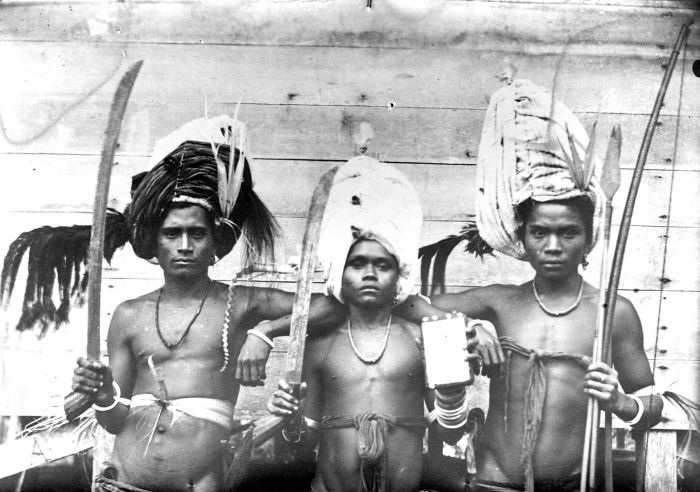
A temple in Lombok C1925

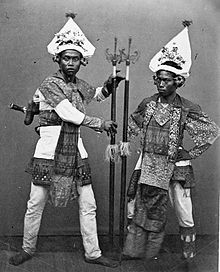
Masters of Ceremonies employed by the Balinese rulers of Lombok C1870.

The island's indigenous Sasak people are predominantly Muslim however before the arrival of Islam Lombok experienced a long period of Hindu and Buddhist influence that reached the island through Java. A minority Balinese Hindu culture remains in Lombok. Islam may have first been brought to Lombok by traders arriving from Sumbawa in the 17th century who then established a following in eastern Lombok. Other accounts describe the first influences arriving in the first half of the sixteenth century. According to the palm leaf manuscript Babad Lombok which contains the story of Lombok describes how Sunan Prapen was sent by his father The Susuhunan Ratu of Giri on a military expedition to Lombok and Sumbawa in order to convert the population and propagate the new religion. However the new religion took on a highly syncretistic character, frequently mixing animist and Hindu-Buddhist beliefs and practices with Islam.
A more orthodox version of Islam increased in popularity in the early twentieth century. The Indonesian government agamaization programs (acquiring of a religion) in Lombok during 1967 and 1968 led to a period of some considerable confusion in religious allegiances and practices. These agamaization programs later led to the emergence of more conformity in religious practices in Lombok. The Hindu minority religion is still practised in Lombok alongside the majority Muslim religion.
Hinduism is followed by ethnic Balinese immigrants and by a minority of the indigenous Sasak. All the main Hindu religious ceremonies are celebrated in Lombok and there are many villages throughout Lombok that have a Hindu majority population. According to local legends two of the oldest villages on the island, Bayan and Sembalun, were founded by a prince of Majapahit.
The Nagarakertagama, the 14th century palm leaf poem that was found on Lombok, places the island as one of the vassals of the Majapahit empire. This manuscript contained detailed descriptions of the Majapahit Kingdom and also affirmed the importance of Hindu-Buddhism in the Majapahit empire by describing temple, palaces and several ceremonial observances.
Christianity is practised by a small minority including some ethnic Chinese and immigrants from East Nusa Tenggara. The history of a small Arab community in Lombok has history dating back to early settlement by traders from Yemen. The community is still evident mainly in Ampenan, the old Port of Mataram. Due to the siting of a UNHCR refugee centre in Lombok some refugees from middle eastern countries have intermarried with Lombok people[citation needed].
A non-orthodox Islamic group found only on Lombok are the Wektu Telu ("Three times"), who pray three times daily, instead of the five times stipulated in the Quran. Waktu Telu beliefs are entwined with animism, and is influenced not only by Islam, but also Hinduism and pantheistic beliefs. There are also remnants of Boda who maintain Pagan Sasak beliefs and could be representative of an original Sasak culture, undiluted by later Islamic innovations.

Economy and politics
Many influences of animist belief prevail within the Sasak people, most of whom believe in the existence of spirits or ghosts. They regard both food and prayer as indispensable whenever they seek to communicate with spirits, including the dead and ritualistic traditional practices endure.[Traditional magic is practised to ward off evil and illness and to seek solutions to disputations and antipathy. Magic may be practised by an individual alone but normally a person experienced in such things is sought out to render a service. Normally money or gifts are made to this person and the most powerful practitioners are treated with considerable respect

Many of the visitors to Lombok and much of the islands goods come across the Lombok Strait by sea or air links. Only 25 miles separate the two islands. Lombok is often marketed as “an unspoiled Bali,” or “Bali’s sister island.” Currently with support of the central government Lombok and Sumbawa are being developed as Indonesia 2nd destination for international and domestic tourism. Lombok has retained a more natural, uncrowded and undeveloped environment, which attract travelers who come to enjoy its relaxed pace and the opportunity to explore the island's unspoiled, spectacular natural beauty. The more contemporary marketing campaigns for Lombok/Sumbawa seek to differentiate from Bali and promote the island of Lombok as a stand alone destination. The opening of the new Lombok International Airport on 1 October 2011 will assist in this endeavour.


                                                                  Local Sasak children

Nusa Tenggara Barat and Lombok may be considered economically depressed by First World standards and a large majority of the population live in poverty. Still, the island is fertile, has sufficient rainfall in most areas for agriculture, and possesses a variety of climate zones. Consequently, food in abundant quantity and variety is available inexpensively at local farmer's markets, though locals still suffer from famine due to drought and subsistence farming. A family of 4 can eat rice, vegetables, and fruit for as little as US$0.50. Even though a family's income may be as small as US$1.00 per day from fishing or farming, many families are able to live a contented and productive life on such astonishingly small incomes. The people of Lombok however are coming under increasing pressure from rising food and fuel prices and access to housing, education and health services remains difficult for many of the islands indigenous population.
The percentage of the population living in poverty in urban areas of Nusa Tenggara Barat in 2008 was 29.47% and in 2009 it was 28.84%. For those living in rural areas in 2008 it was 19.73% and in 2009 it reduced marginally to 18.40% For combined urban and village the figures were 23.81% and in 2009 it fell slightly to 22.78%.
In Mataram in 2008 the percentage of the population that was unmarried was 40.74%, married 52.01%, divorced 2.51% and widowed 4.75%

Tourism

One of the unique traditional crafts from Lombok
Tourism is an important source of income on Lombok. The most developed tourism area of the island is on the west coast of the island and is centered about the township of Senggigi. The immediate surrounds of the township contain the most developed tourism facilities. The west coast coastal tourism strip is spread along a 30 km strip following the coastal road north from Mataram and the nearby current airport at Ampenan. The principal tourism area extends to Tanjung in the northwest at the foot of Mount Rinjani and includes the Sire and Medana Peninsulas and the highly popular Gili Islands lying immediately offshore. These three small islands are most commonly accessed by boat from Bangsal near Pemenang, Teluk Nare a little to the south, or from further south at Senggigi and Mangsit beach. A large number of hotels and resorts offer accommodations ranging from budget to luxurious. Recently direct fast boat services have been running from Bali making a direct connection to the Gili islands. Although rapidly changing in character, the Gili islands still provide both a lay-back backpacker's retreat and a high class resort destination.
Other tourist destinations include Mount Rinjani, Gili Bidara, Gili Lawang, Narmada Park and Mayura Park and Kuta (distinctly different from Kuta, Bali).The Kuta area is also famous for its beautiful, largely deserted, white sand beaches. Sekotong, in southwest Lombok, is popular for its numerous and diverse scuba diving locations. South Lombok surfing is considered some of the best in the world and includes Desert Point at Banko Banko in the southwest of the island. The northern west coast near Tanjung has many new upmarket hotel and villa developments centreed about the Sire and Medana peninsular nearby to the Gili islands and a new boating marina
 at Medana bay. These new developments complement the already existing 5 star resorts and a large golf course already established there.


PRE 2000

Tourist development started in the mid-1980s, when Lombok attracted attention as an 'unspoiled' alternative to Bali. Initially, low budget bungalows proliferated at places like the Gili islands and Kuta, Lombok on the South Coast. These tourist accommodations were largely owned by and operated by local business entrepreneurs. Areas in close proximity to the airport, places like Sengiggi, experienced rampant land speculation for prime beachfront land by big businesses from outside Lombok.
In the 1990s the national government in Jakarta began to take an active role in planning for and promoting Lombok's tourism. Private organizations like the Bali Tourism Development Corporation (BTDC) and the Lombok Tourism Development Corporation (LTDC) were formed. LTDC prepared detailed land use plans with maps and areas zoned for tourist facilities. Large hotels provide primary employment for the local population. Ancillary business, ranging from restaurants to art shops have been started by local businessmen. These businesses provide secondary employment for local residents.
1997 TO 2007
The 1997 Asian Financial Crisis and the fall of Suharto regime in 1998 marked the beginning a decade of setbacks for tourism. Spurred by rapid devaluation of the currency and the transition to true democracy caused all of Indonesia to experience a period of domestic unrest. Many of Indonesian Provinces struggled with elements of the population desiring autonomy or independence from the Republic of Indonesia. At the same time fanatical Islamic terrorism in Indonesia further aggravated domestic unrest across the archipelago.
In Jan 2000, radical Islamic agitators from the newly formed Jemaah Islamiyah provoked religious and ethnic violence in the Ampenan area of Mataram and the southern area of Senggigi. Many foreign expatriates and tourists were temporarily evacuated to Bali. Numerous foreign embassies issued Travel Warnings advising of the potential danger of traveling to Indonesia.
Subsequently, the 2002 Bali bombings, the 2005 Bali bombings and the Progress of the SARS outbreak in Asia all dramatically impacted tourism activities in Lombok. Tourism was slow to return to Lombok, provoked in part by a worldwide reluctance to travel because of global tensions. Only since 2007–2008, when most developed countries lifted their Travel Warnings[21] has tourism recovered to the pre-2000 levels.

2008 TO THE PRESENT

The years leading up to 2010 has seen a rapid revival and promotion of tourism recovery in the tourism industry. The number of visitors has far surpassed the pre-2000 levels. All signs indicate the long-term trend will see a steady increase in the number of visitor arrivals.
Both the local government and many residents recognise that tourism and services related to tourism will continue to be a major source of income for the island. The island's natural beauty and the customary hospitality of its residents make it an obvious tourist destination.
Lombok retains the allure of an undeveloped and natural environment. Tourism visits to this tropical island are increasing again as both international and local tourists are re-discovering the charms of Lombok. With this new interest comes the development of a number of boutique resorts on the island providing quality accommodation, food and drinks in near proximity to relatively unspoiled countryside.
The Indonesian government is actively promoting both Lombok and neighboring Sumbawa as Indonesia's number two tourism destination after Bali. The President of Indonesia, Susilo Bambang Yudhoyono, the Ministry of Cultural and Tourism and the regional Governor have made public statements supporting the development of Lombok as a tourism destination and setting a goal of 1 million visitors annually by the year 2012 for the combined destination of Lombok and Sumbawa. [22][23] This has seen infrastructure improvements to the island including road upgrades and the construction of a much delayed new International airport in the islands south.

TRANSPORTATION

Lombok International Airport (Bandara Internasional Lombok) is south west of the small regional city of Praya in South central Lombok. It commenced operations on 1 October 2011. It replaced Selaparang airport near Ampenan.It is the only operational international airport within the province of West Nusa Tenggara (Nusa Tenggara Barat).
Selaparang Airport in Ampenan was closed for operations on the evening of 30 September 2011. It previously provided facilities for domestic services to Java, Bali, and Sumbawa and international services to Singapore to Kuala Lumpur via Surabaya and Jakarta. It was the island's original airport and is situated on Jalan Adi Sucipto on the north western outskirts of Mataram. The terminals and basic airport infrastructure remain intact but it is closed to all civil airline traffic.
Lembar Harbour seaport in the southwest has shipping facilities and a ferry for road vehicles and passenger services. Labuhan Lombok ferry port on the east coast provides a ferry for road vehicles and passenger services to Poto Tano on Sumbawa.
Pelni Shipping Line provide a national network of passenger ship services throughout the Indonesian archipelago Pelni have offices in Ampenan.
Fastboat services are provided for passenger movements between the nearby island of Bali and principally serve the Gili Islands, with some limited onward traffic to the Lombok mainland. Landfall is on one or more of the Gili islands dependent upon the operator and on the mainland is at either Teluk Nare/Teluk Kodek, or the township of Senggigi, both on the nearby west coast of the main island of Lombok. The services are controversial in nature in that the majority of the services use craft unsuitable to the conditions, with questionable safety standards and inadequate levels of crew training for operations in open water.

WATER RESOURCE

Areas in southern Lombok Island were classified as arid and prone to water shortages due to low rainfall and lack of water sources. On May 2011, grounbreaking ceremony has done to initial the Pandanduri dam construction which will span about 430 hectares and cost estimated Rp.800 billion ($92.8 million) to accommodate about 25.7 million cubic meters of water and be able to irrigate 10,350 hectares of farmland. The project would be finished by the next five years.
References:
·         L, Klemen (1999-2000). "Forgotten Campaign: The Dutch East Indies Campaign 1941-1942"

Indonesian Cuisine

Indonesian cuisine is one of the most vibrant and colourful cuisines in the world, full of intense flavour. It is diverse, in part because...